Tuesday, May 25, 2010


Moon Lightning.

It's rare that you can catch a lightning storm and the moon in the same shot.
I shot this from Farmers Lane - just before all hell broke loose.
I'll post more tomorrow.
-Steve Douglass
Monday, May 24, 2010
A great e-book about tornadoes for your kids!

Hello!
I'm proud to announce that my first e-book written for 5 to 10 year olds is now on sale for the Amazon Kindle and (or) for download as a Adobe Acrobat file for your PC or Mac!
Mekay's 1st life is the story of a little girl, he grandfather, a farm cat named Mekay and their encounter with coyotes and tornadoes.
Read more about it HERE.
I hope you'll consider buying Mekay's 1st Life!
-Steve Douglass
Saturday, May 22, 2010


Friday, May 21, 2010
Video highlights- last night's storm chase.
The storms that blew up near Claude weren't tornadic- but they sure were beautiful. I'll post some photos soon.
Slight risk today ...

.THERE IS A SLGT RISK OF SVR TSTMS OVER PORTIONS OF THE LOWER OH
VALLEY ACROSS THE TN VALLEY TO THE SOUTH AND SOUTHEAST...
...THERE IS A SLGT RISK OF SVR TSTMS FROM SERN WY AND ADJACENT AREAS
OF SD AND NEB SOUTH ACROSS ERN CO AND THE SRN HIGH PLAINS...
...SYNOPSIS...
MID LEVEL FLOW WILL REMAIN QUITE AMPLIFIED ACROSS THE CONUS INTO THE
WEEKEND AS ONE WELL-DEFINED DISTURBANCE MOVES ACROSS THE MIDWEST
THROUGH TODAY AND ANOTHER SUBSTANTIAL TROUGH DEEPENS OVER THE WEST
AND ROCKIES. TRANSIENT RIDGING WILL MOVE FROM THE PLAINS TO THE MS
VALLEY THIS PERIOD.
...CNTRL/SRN HIGH PLAINS...
ANOTHER STRONG SHORT WAVE TROUGH COMING ACROSS THE CA/ORE COAST THIS
MORNING WILL ROTATE THROUGH THE LARGER-SCALE TROUGH ESTABLISHED
ACROSS THE WEST THROUGH TONIGHT. MID LEVEL SWLY FLOW IS FORECAST TO
STRENGTHEN ACROSS ROCKIES AND ADJACENT HIGH PLAINS THROUGH THIS
AFTERNOON AS LEE CYCLOGENESIS OCCURS OVER WY/CO. LOW LEVEL MOISTURE
...CURRENTLY MARGINAL FOR DEEP CONVECTION...WILL INCREASE NWWD AS
PRESSURE FALLS COMMENCE IN EARNEST LATER THIS MORNING AND LOW LEVEL
SELY FLOW STRENGTHENS. COMBINED WITH BOUNDARY LAYER HEATING AND
STEEPENING LAPSE RATES ALOFT...EXPECT A GENERALLY N-S AXIS OF
INSTABILITY TO DEVELOP WITH MLCAPE VALUES RANGING FROM ABOUT 500
J/KG ACROSS SERN WY...TO AS HIGH AS 2000 J/KG OVER PARTS OF TX.
LACK OF STRONGER DESTABILIZATION WITH NWWD EXTENT WILL MOST LIKELY
BE COMPENSATED FOR BY STRONG DYNAMIC FORCING FOR ASCENT WITH THE
APPROACHING SHORT WAVE...AS WELL AS OROGRAPHIC/UPSLOPE FLOW. THESE
INFLUENCES WILL LEAD TO THUNDERSTORM DEVELOPMENT...FIRST OVER THE
HIGHER TERRAIN TO THE WEST...AND THEN SPREADING EAST INTO AXIS OF
MODEST INSTABILITY FROM SERN WY ACROSS NERN CO. PRONOUNCED SPEED
SHEAR...AS WELL AS STRONG DIRECTIONAL SHEAR LOWER IN THE STORM
UPDRAFT WILL LEAD TO ROTATING CELLS CAPABLE OF VERY LARGE HAIL AND
PERHAPS A COUPLE OF TORNADOES.
FARTHER SOUTH ALONG THE DRY LINE...FROM SERN CO TO WEST TX/ERN
NM...STORM INITIATION BECOMES MORE UNCERTAIN. LACK OF STRONGER
HEIGHT FALLS/FORCING AND DEGREE OF CONVECTIVE INHIBITION SUGGEST
THAT STORM DEVELOPMENT WILL BE ISOLATED ALONG THIS AXIS. CONSENSUS
EXISTS AMONG HIGH RESOLUTION MODELS AND THE NAM THAT SURFACE HEATING
AND WEAK BACKGROUND ASCENT MAY BE ADEQUATE FOR AT LEAST A COUPLE OF
STORMS TO INITIATE...ESPECIALLY FROM TX PNHDL SOUTH TO NEAR THE
PECOS RIVER. SHEAR PROFILES WILL BE SUPPORTIVE OF SUPERCELLS AND
LARGE HAIL SHOULD BE THE PRIMARY HAZARD FROM THIS ACTIVITY THAT MAY
DECAY RATHER QUICKLY AFTER DARK.
Wednesday, May 19, 2010


Storm chase 5-18-2010


A few from last night's chase in the NW texas Panhandle. Check back often. More to come.
Click to enlarge:

-Steve Douglass
Tuesday, May 18, 2010
Looking up into the mesocyclone!
This is just one video of what weather we encountered tonight. You can't forget to look up!
Moe post tomorrow - time for bed.
-Steve Douglass
Moe post tomorrow - time for bed.
-Steve Douglass
There will be tornadoes today ...
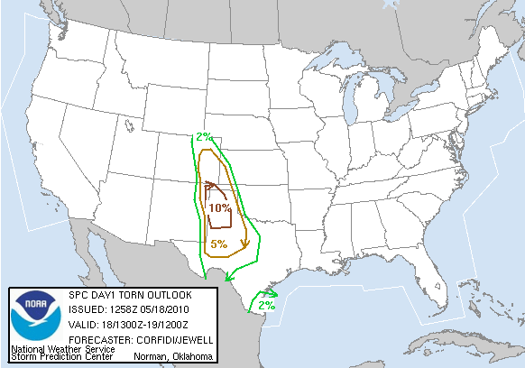
.CNTRL/SRN HI PLNS THROUGH EARLY WED...
INCREASING FORCING FOR ASCENT...STRENGTHENING/DIFFLUENT UPR FLOW
...LOW LVL MOISTURE RETURN...AND SFC CYCLOGENESIS WILL SUPPORT A
SUBSTANTIAL SVR POTENTIAL OVER THE CNTRL/SRN HI PLNS TODAY/TONIGHT.
STG/SVR TSTMS SHOULD FORM MORE OR LESS SIMULTANEOUSLY IN
CONFLUENT...MODERATELY UPSLOPE FLOW OVER ERN CO/NE NM...AND ALONG
N-S DRYLINE NEAR THE NM-TX BORDER.
STEEPENING LOW TO MID LVL LAPSE RATES...MODERATE INSTABILITY AND STG
VERTICAL SHEAR/VEERING WIND PROFILES WILL BE FAVORABLE FOR
SUPERCELLS...WITH LARGE HAIL AND SOME TORNADOES. THIS THREAT SHOULD
BE GREATEST LATE THIS AFTN/EARLY TONIGHT OVER SE CO/FAR ERN NM AND
MUCH OF W TX. WITH MODERATE SLY LLJ LIKELY TO INCREASE IN RESPONSE
TO CONTINUED EWD PROGRESSION OF GRT BASIN UPR TROUGH...THE
RELATIVELY GREATEST TORNADO THREAT A BIT LATER THIS EVE MAY EXIST
OVER PARTS OF THE TX PANHANDLE AND ADJACENT TX S PLNS...NEAR SFC
WARM FRONT/CONVECTIVE OUTFLOW/DRY LINE INTERSECTION.
OTHERWISE...THE INCREASING LLJ SHOULD SUPPORT UPSCALE DEVELOPMENT
INTO ONE OR MORE SE-MOVING MCSS TONIGHT. WITH EMBEDDED SUPERCELLS
AND SUSTAINED STORMS/BOWING SEGMENTS...THESE LIKELY WILL YIELD A
CONTINUED THREAT FOR SVR HAIL...DMGG WIND...AND PERHAPS AN ISOLD
TORNADO INTO PARTS OF NW TX AND POSSIBLY WRN OK
Monday, May 17, 2010
Slight risk today ...

SPC:
CURRENT SEVERE MCS NWRN TX TRACKING SEWD INTO FAVORABLE INSTABILITY
AND SHOULD CONTINUE. ADDITIONALLY AS LAPSE RATES STEEPEN WITH
DAYTIME HEATING THUNDERSTORMS WILL DEVELOP OFF HIGHER TERRAIN ERN NM
INTO SERN CO. WITH MLCAPES TO 2000 J/KG...LAPSE RATES ABOVE 8C/KM
AND 35 KT OF SHEAR...CONDITIONS WILL BE FAVORABLE FOR A FEW
SUPERCELLS BY MID/LATE AFTERNOON WITH PRIMARY THREAT VERY LARGE
HAIL. HAVE EXTENDED THE RISK INTO SERN CO FOR THIS AFTERNOON AND
SWRN KS FOR THIS EVENING AS THE SAME SHEAR AND INSTABILITY
CONDITIONS EXPECTED TO BE AVAILABLE AS FURTHER S.
Sunday, May 16, 2010

NWS says tornadoes were EF-4s

NORMAN, Okla. (AP) - The National Weather Service has upgraded two of the tornadoes that hit central Oklahoma on Monday to EF-4 status.
The agency's Norman office said Friday a twister that traveled from Moore to Choctaw and another that started in Norman and traveled through Little Axe to Pink both had wind speeds of between 166 mph and 200 mph.
Tornadoes are rated from 0 to 5 on the Enhanced Fujita Scale based on the damage they cause. The weather service originially rated the two tornadoes as EF-3 storms.
Four other twisters in Oklahoma on Monday have been rated as EF-3. Fewer than 5 percent of tornadoes are rated as EF-3 or higher.
Rick Smith, a warning coordination meteorologist with the weather service, says the agency upgraded the status of the two storms after looking at photographic evidence and visiting damage sites that had previously been closed off.
(Copyright 2010 by The Associated Press. All Rights Reserved.)
Possible severe weather Wednesday.

DAY 3 CONVECTIVE OUTLOOK
NWS STORM PREDICTION CENTER NORMAN OK
0212 AM CDT SUN MAY 16 2010
VALID 181200Z - 191200Z
...THERE IS A SLGT RISK OF SVR TSTMS ACROSS PARTS OF WEST TX AND THE
TX PANHANDLE...
...SRN AND CNTRL HIGH PLAINS...
AN UPPER-LEVEL LOW IS FORECAST TO MOVE ACROSS THE INTERMOUNTAIN WEST
TUESDAY AS A MID-LEVEL JET ROUNDS THE BASE OF THE TROUGH. AT THE
SFC...A MOIST AXIS SHOULD EXIST ACROSS WEST TX EXTENDING NNWWD INTO
SE CO WHERE MODEL FORECASTS DEVELOP MODERATE INSTABILITY BY TUESDAY
AFTERNOON. AS LARGE-SCALE ASCENT INCREASES DUE TO THE APPROACH OF
THE UPPER-LEVEL TROUGH AND A CAPPING INVERSION WEAKENS...CONVECTIVE
DEVELOPMENT SHOULD OCCUR NEAR THE EXIT REGION OF THE MID-LEVEL JET
FROM SE CO SSEWD ONTO THE CAPROCK OF WEST TX. FORECAST SOUNDINGS
ALONG THIS CORRIDOR AT 00Z SHOW STRONG DEEP LAYER SHEAR PROFILES
ASSOCIATED WITH THE MID-LEVEL JET AND STEEP MID-LEVEL LAPSE RATES
SUGGESTING A THREAT FOR SUPERCELLS WITH LARGE HAIL MAY DEVELOP. THE
GREATEST POTENTIAL FOR SEVERE WOULD BE ON THE NRN EDGE OF STRONGEST
INSTABILITY ACROSS THE TX PANHANDLE WHERE A SLIGHT RISK HAS BEEN
INTRODUCED.
LINK
Wednesday, May 12, 2010

Tuesday, May 11, 2010
Monday, May 10, 2010
Oklahoma City hit by two tornados!
a onblur="try {parent.deselectBloggerImageGracefully();} catch(e) {}" href="https://blogger.googleusercontent.com/img/b/R29vZ2xl/AVvXsEhwMv09o6jLu1XfF3gmx2NWWXXzd8fedTDqlSYXfmWdFameeta3vRzafiJJsp4Hy8tLNAal6sEeJACSypyjDstEx1Ir3j3LHW_jZoixGgTLUCSUlpQ60NW2DEDl4dWzhOB2Kfb8thIjm3Y/s1600/Screen+shot+2010-05-10+at+6.08.16+PM.png">


Details are sketchy - but here are some screen grabs of the damage from KOCO TV.
Damage reported in Norman and in SE OKC.
Upate: Lots of cars tossed at I-40 & Choctaw. Rescue and PD going car to car.
LIVE COVERAGE VIA KOCO HERE
UPDATE: (CNN) -- At least three people were killed and several others critically injured in Oklahoma on Monday after a severe weather system spawned multiple tornadoes across the state, including a massive twister recorded on video over Norman, Oklahoma.
The state medical examiner's office confirmed three deaths as a result of the storm, spokeswoman Cherokee Ballard said. One person died in southeastern Oklahoma City and another in Cleveland County. Ballard did not know the location of the third death.
Brenda Finkle, director of corporate communications for Norman Regional Health System, said the company's hospital in Norman admitted eight patients Monday night in critical condition with crush injuries and head trauma.
At least 25 other people filled the waiting room of Norman Regional Hospital with lacerations and head wounds, Finkle said, adding hospital staff expected more patients to continue to seek treatment.
Another 20 people were either getting medical care or awaiting treatment at Moore Medical Center, just north of Norman, according to Finkle.
OU Medical Center in Oklahoma City, Oklahoma, received two patients with broken bones, according to spokesman Allen Poston.
The Oklahoma Department of Emergency Management reported seven injuries.
Video out of Norman showed overturned cars, snapped utility poles, downed trees and severely damaged homes. Several mobile homes were blown to pieces in one neighborhood where debris littered yards and streets alongside large trees ripped straight from the ground.
A truck stop east of Oklahoma City was demolished, taking a direct hit from one of the tornadoes, according to a spokeswoman for Love's Travel Stops and Country Stores.
Motorists pulled off Interstate 40 and sought shelter in the truck stop's large coolers and restrooms before the tornado tore the roof off the building, blew out car windows and overturned tractor-trailers, spokeswoman Christina Dukeman said.
Video showed people outside the truck stop receiving treatment for minor injuries. Laura O'Leary, a spokeswoman for the Emergency Medical Services Authority, said seven people were transported from around the immediate area to local hospitals in good and fair condition, "a miraculously low number ... considering the volume of area the tornado covered."
Love's employee Charlescie Greenway said she and two other women made it to one cooler before the twister tore through the building.
"The three of us were kind of trapped in there, holding the door shut, praying to God that we don't die and that everybody else was safe," Greenway told CNN affiliate KWTV, adding, "it was really scary -- the wind was like trying to pull the door off the latch."
Sammy Ward and his partner rode the twister out in their truck in the parking lot.
"It started hailing and then it quit hailing and then all of a sudden the wind hit and it just went dark and here went everything," Ward told KWTV. "Trucks went to rocking ... and next thing we know the whole roof and everything was gone."
Ward, who said he felt "very lucky," said the event lasted two to three minutes.
Albert Ashwood, director of the state emergency management department, said crews were working to assess the damages in at least 13 counties, adding "numerous" homes had been affected.
The American Red Cross opened at least two shelters in McCloud, Oklahoma, and Tecumseh, Oklahoma, and continued to assess needs across the state.
More than 31,000 homes were without power in the metro Oklahoma City area -- nearly 15,000 in Norman alone, according to Oklahoma Gas & Electric.
Ashwood said preliminary reports out of Norman indicate the damages are "similar to what you would see with an EF3" tornado, referring to the Enhanced Fujita Scale for measuring the strength of tornadoes. An EF3 is capable of producing winds up to 165 mph.
CNN iReporter Rebecca Barbato said tornado sirens were going off in her neighborhood in Moore, just north of Norman, when tennis-ball-sized hail began raining down on her roof.
Other tornadoes were reported in Yukon, Medford and Shawnee in Oklahoma, and in Wichita, Kansas.
The storms struck around 5 p.m. CT (6 p.m. ET).
Meteorologists warned throughout the day Monday of the potential for tornadoes.

Subscribe to:
Posts (Atom)
