All original images (C) Steve Douglass unless otherwise noted.

All original images (C) Steve Douglass unless otherwise noted. Permission required for commercial use or publishing.

ABC7's Live Scanner Feed!

>

Wednesday, May 26, 2010

The Maelstrom

CLICK TO ENLARGE


With no storms to chase tonight - I spent most of this evening editing this image in Photoshop. It was shot Monday night as the severe storms raked the city and the sirens were sounding.

When I first uploaded it into my Mac - I saw it had potential - but it had major problems. It was filled with electromagnetic noise (due to the lightning) underexposed in parts of the image and because the clouds were in motion during the 15 second exposure parts of it were blurred.

I knew it would take some serious work in CS-4 but If I could bring out of the mess the epic scene I beheld with my more sensitive eyes - it would be worth it.

- I spent over three hours "fixing" bringing out of the digital -muck this final view of that amazing storm.

I call it "The Maelstrom" and gives you a good idea what was going on in the skies over Amarillo that caused us to all lose so much sleep.


SAVE A STARVING PHOTOGRAPHER - BUY THIS PRINT!

-Steve Douglass

"Some day I'll be a thunderstorm - again."

Wild wave ...


(C) Steve Douglass

The little jet and the giant face ..


A thunderhead, that popped up yesterday evening, appears to be looking up at a high-altitude jet.

-Steve Douglass

Tuesday, May 25, 2010

In so little time ...


This sequence of photos (taken five minutes apart) show how fast a few clouds can turn into a storm. Photographed over SW Amarillo last PM.

- Steve Douglass

Cloud shadows.


One thing I love about storm is how their color and dimensionality interact. In this photo, the small cloud towers growing in the foreground (left bottom) cast a giant shadow on the super-cell thunderstorm in the background.

- Steve Douglass

Bloody sky ...

Sodium vapor lights on Loop 335 tinge the approaching storm blood-red.

-Steve Douglass

Lightshow ...

Moon Lightning.


It's rare that you can catch a lightning storm and the moon in the same shot.
I shot this from Farmers Lane - just before all hell broke loose.
I'll post more tomorrow.

-Steve Douglass

Monday, May 24, 2010

A great e-book about tornadoes for your kids!


Hello!
I'm proud to announce that my first e-book written for 5 to 10 year olds is now on sale for the Amazon Kindle and (or) for download as a Adobe Acrobat file for your PC or Mac!

Mekay's 1st life is the story of a little girl, he grandfather, a farm cat named Mekay and their encounter with coyotes and tornadoes.

Read more about it HERE.

I hope you'll consider buying Mekay's 1st Life!

-Steve Douglass

Saturday, May 22, 2010

Supercell in Carson County 5-21-10

Click to enlarge:


Big hail south of Groom on FM 294:


Friday, May 21, 2010

Video highlights- last night's storm chase.

The storms that blew up near Claude weren't tornadic- but they sure were beautiful. I'll post some photos soon.

Slight risk today ...


.THERE IS A SLGT RISK OF SVR TSTMS OVER PORTIONS OF THE LOWER OH
VALLEY ACROSS THE TN VALLEY TO THE SOUTH AND SOUTHEAST...

...THERE IS A SLGT RISK OF SVR TSTMS FROM SERN WY AND ADJACENT AREAS
OF SD AND NEB SOUTH ACROSS ERN CO AND THE SRN HIGH PLAINS...

...SYNOPSIS...
MID LEVEL FLOW WILL REMAIN QUITE AMPLIFIED ACROSS THE CONUS INTO THE
WEEKEND AS ONE WELL-DEFINED DISTURBANCE MOVES ACROSS THE MIDWEST
THROUGH TODAY AND ANOTHER SUBSTANTIAL TROUGH DEEPENS OVER THE WEST
AND ROCKIES. TRANSIENT RIDGING WILL MOVE FROM THE PLAINS TO THE MS
VALLEY THIS PERIOD.

...CNTRL/SRN HIGH PLAINS...
ANOTHER STRONG SHORT WAVE TROUGH COMING ACROSS THE CA/ORE COAST THIS
MORNING WILL ROTATE THROUGH THE LARGER-SCALE TROUGH ESTABLISHED
ACROSS THE WEST THROUGH TONIGHT. MID LEVEL SWLY FLOW IS FORECAST TO
STRENGTHEN ACROSS ROCKIES AND ADJACENT HIGH PLAINS THROUGH THIS
AFTERNOON AS LEE CYCLOGENESIS OCCURS OVER WY/CO. LOW LEVEL MOISTURE
...CURRENTLY MARGINAL FOR DEEP CONVECTION...WILL INCREASE NWWD AS
PRESSURE FALLS COMMENCE IN EARNEST LATER THIS MORNING AND LOW LEVEL
SELY FLOW STRENGTHENS. COMBINED WITH BOUNDARY LAYER HEATING AND
STEEPENING LAPSE RATES ALOFT...EXPECT A GENERALLY N-S AXIS OF
INSTABILITY TO DEVELOP WITH MLCAPE VALUES RANGING FROM ABOUT 500
J/KG ACROSS SERN WY...TO AS HIGH AS 2000 J/KG OVER PARTS OF TX.

LACK OF STRONGER DESTABILIZATION WITH NWWD EXTENT WILL MOST LIKELY
BE COMPENSATED FOR BY STRONG DYNAMIC FORCING FOR ASCENT WITH THE
APPROACHING SHORT WAVE...AS WELL AS OROGRAPHIC/UPSLOPE FLOW. THESE
INFLUENCES WILL LEAD TO THUNDERSTORM DEVELOPMENT...FIRST OVER THE
HIGHER TERRAIN TO THE WEST...AND THEN SPREADING EAST INTO AXIS OF
MODEST INSTABILITY FROM SERN WY ACROSS NERN CO. PRONOUNCED SPEED
SHEAR...AS WELL AS STRONG DIRECTIONAL SHEAR LOWER IN THE STORM
UPDRAFT WILL LEAD TO ROTATING CELLS CAPABLE OF VERY LARGE HAIL AND
PERHAPS A COUPLE OF TORNADOES.

FARTHER SOUTH ALONG THE DRY LINE...FROM SERN CO TO WEST TX/ERN
NM...STORM INITIATION BECOMES MORE UNCERTAIN. LACK OF STRONGER
HEIGHT FALLS/FORCING AND DEGREE OF CONVECTIVE INHIBITION SUGGEST
THAT STORM DEVELOPMENT WILL BE ISOLATED ALONG THIS AXIS. CONSENSUS
EXISTS AMONG HIGH RESOLUTION MODELS AND THE NAM THAT SURFACE HEATING
AND WEAK BACKGROUND ASCENT MAY BE ADEQUATE FOR AT LEAST A COUPLE OF
STORMS TO INITIATE...ESPECIALLY FROM TX PNHDL SOUTH TO NEAR THE
PECOS RIVER. SHEAR PROFILES WILL BE SUPPORTIVE OF SUPERCELLS AND
LARGE HAIL SHOULD BE THE PRIMARY HAZARD FROM THIS ACTIVITY THAT MAY
DECAY RATHER QUICKLY AFTER DARK.

Wednesday, May 19, 2010

Can you see it?


Adjust exposure a bit .. and voila!


(C) Steve Douglass

Storm chase 5-18-2010


A few from last night's chase in the NW texas Panhandle. Check back often. More to come.

Click to enlarge:


-Steve Douglass

Tuesday, May 18, 2010

Looking up into the mesocyclone!

This is just one video of what weather we encountered tonight. You can't forget to look up!


Moe post tomorrow - time for bed.

-Steve Douglass

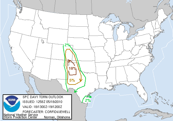
There will be tornadoes today ...


.CNTRL/SRN HI PLNS THROUGH EARLY WED...
INCREASING FORCING FOR ASCENT...STRENGTHENING/DIFFLUENT UPR FLOW
...LOW LVL MOISTURE RETURN...AND SFC CYCLOGENESIS WILL SUPPORT A
SUBSTANTIAL SVR POTENTIAL OVER THE CNTRL/SRN HI PLNS TODAY/TONIGHT.
STG/SVR TSTMS SHOULD FORM MORE OR LESS SIMULTANEOUSLY IN
CONFLUENT...MODERATELY UPSLOPE FLOW OVER ERN CO/NE NM...AND ALONG
N-S DRYLINE NEAR THE NM-TX BORDER.

STEEPENING LOW TO MID LVL LAPSE RATES...MODERATE INSTABILITY AND STG
VERTICAL SHEAR/VEERING WIND PROFILES WILL BE FAVORABLE FOR
SUPERCELLS...WITH LARGE HAIL AND SOME TORNADOES. THIS THREAT SHOULD
BE GREATEST LATE THIS AFTN/EARLY TONIGHT OVER SE CO/FAR ERN NM AND
MUCH OF W TX. WITH MODERATE SLY LLJ LIKELY TO INCREASE IN RESPONSE
TO CONTINUED EWD PROGRESSION OF GRT BASIN UPR TROUGH...THE
RELATIVELY GREATEST TORNADO THREAT A BIT LATER THIS EVE MAY EXIST
OVER PARTS OF THE TX PANHANDLE AND ADJACENT TX S PLNS...NEAR SFC
WARM FRONT/CONVECTIVE OUTFLOW/DRY LINE INTERSECTION.

OTHERWISE...THE INCREASING LLJ SHOULD SUPPORT UPSCALE DEVELOPMENT
INTO ONE OR MORE SE-MOVING MCSS TONIGHT. WITH EMBEDDED SUPERCELLS
AND SUSTAINED STORMS/BOWING SEGMENTS...THESE LIKELY WILL YIELD A
CONTINUED THREAT FOR SVR HAIL...DMGG WIND...AND PERHAPS AN ISOLD
TORNADO INTO PARTS OF NW TX AND POSSIBLY WRN OK

Monday, May 17, 2010

Slight risk today ...


SPC:


CURRENT SEVERE MCS NWRN TX TRACKING SEWD INTO FAVORABLE INSTABILITY
AND SHOULD CONTINUE. ADDITIONALLY AS LAPSE RATES STEEPEN WITH
DAYTIME HEATING THUNDERSTORMS WILL DEVELOP OFF HIGHER TERRAIN ERN NM
INTO SERN CO. WITH MLCAPES TO 2000 J/KG...LAPSE RATES ABOVE 8C/KM
AND 35 KT OF SHEAR...CONDITIONS WILL BE FAVORABLE FOR A FEW
SUPERCELLS BY MID/LATE AFTERNOON WITH PRIMARY THREAT VERY LARGE
HAIL. HAVE EXTENDED THE RISK INTO SERN CO FOR THIS AFTERNOON AND
SWRN KS FOR THIS EVENING AS THE SAME SHEAR AND INSTABILITY
CONDITIONS EXPECTED TO BE AVAILABLE AS FURTHER S.

Sunday, May 16, 2010

Sunday Storm over Sunday Canyon


(C) Steve Douglass

NWS says tornadoes were EF-4s


NORMAN, Okla. (AP) - The National Weather Service has upgraded two of the tornadoes that hit central Oklahoma on Monday to EF-4 status.

The agency's Norman office said Friday a twister that traveled from Moore to Choctaw and another that started in Norman and traveled through Little Axe to Pink both had wind speeds of between 166 mph and 200 mph.

Tornadoes are rated from 0 to 5 on the Enhanced Fujita Scale based on the damage they cause. The weather service originially rated the two tornadoes as EF-3 storms.

Four other twisters in Oklahoma on Monday have been rated as EF-3. Fewer than 5 percent of tornadoes are rated as EF-3 or higher.

Rick Smith, a warning coordination meteorologist with the weather service, says the agency upgraded the status of the two storms after looking at photographic evidence and visiting damage sites that had previously been closed off.

(Copyright 2010 by The Associated Press. All Rights Reserved.)

Click to enlarge!

Please click on each image to enlarge them and see them in their proper color and contrast.